
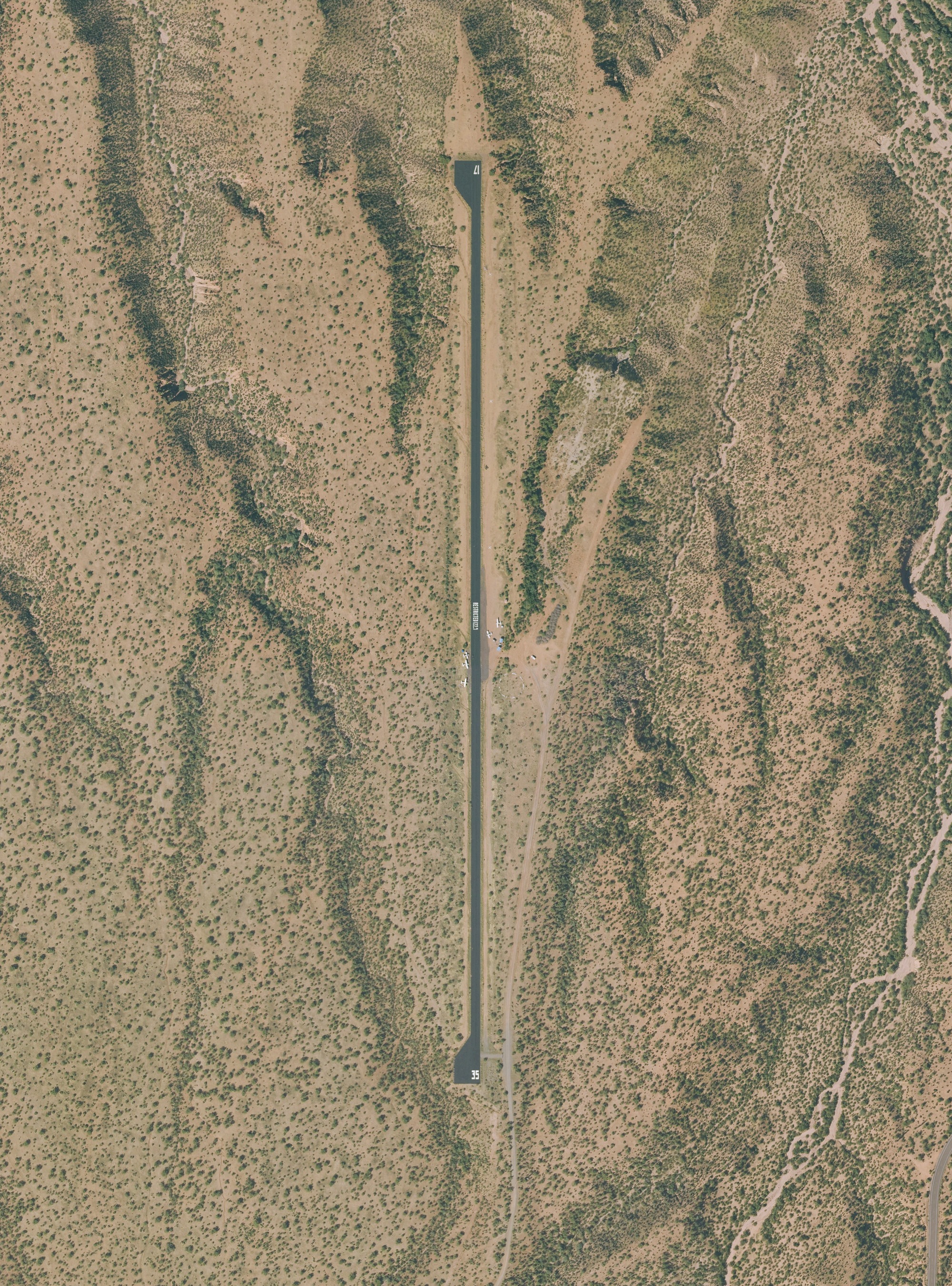
Most backcountry strips in the West are dirt or grass. Grapevine isn't. It's a 3,800-foot asphalt runway in the Tonto National Forest, just south of Roosevelt Lake and about 5 miles southeast of the town of Roosevelt, Ariz., and that pavement is what lets pilots without big tires land there. Pavement in the desert cracks, and water that gets into the cracks softens the base under it. The Arizona Pilots Association (APA), which looks after the strip with the Forest Service and the Recreational Aviation Foundation (RAF), says this fall's crack sealing is finished. General Aviation News carried the news on Nov. 7.
The work
In the APA's October 2026 newsletter, APA president Chris Nugent writes that "Tommy Thomason and the team from Cholla Paving spent several days doing runway maintenance including crack sealing at Grapevine," on what he calls "a 3,800' X 40' airstrip." He calls it "one of the few paved backcountry airstrips in Arizona, and the west."
The money and labor come from a cost-share agreement among the U.S. Forest Service, the RAF and the APA. Under it, the newsletter says, the APA "contributes volunteer labor and funding" to keep Arizona's backcountry strips up. The newsletter doesn't give the cost or the dates of the work.
It isn't the first time. The RAF reported in January 2021 that Jeff Wilson and Tommy Thomason had resealed cracks on the runway, and that $10,000 of material had been bought with Forest Service funds, with the APA and the RAF providing volunteer labor in place of a cash match. The APA's own account from May 2021 describes the first crack sealing, years earlier, as "Three grueling days" of volunteer work. The strip was activated with the FAA in November 2016.
What the FAA record shows
The FAA's airport data, effective Oct. 29, 2026 (as published by AirNav), lists:
- Runway 17/35: 3,800 by 40 feet, asphalt. Left traffic for both runways. Runway 17 is the calm-wind runway.
- Elevation: 2,329 feet, estimated. The APA's brochure gives about 2,500 feet.
- Use: Private use, permission required before landing. Owned and managed by the U.S. Forest Service, Tonto National Forest, Tonto Basin District.
- CTAF: 122.9. Wind indicator and segmented circle. No fuel or services listed.
- Remarks: Use at the pilot's own risk; no training or touch-and-goes. Hazardous runway edges; avoid using it in crosswinds. Rising terrain west of the runway. Military training activity possible. Dirt parking east of the runway at midfield with no tie-downs; limited ramp parking with tie-downs at the west ramp. Avoid overflying Tonto National Monument, 3.25 miles west-northwest, and any campgrounds.
Before going
The APA's Grapevine brochure (dated Feb. 10, 2024) adds what the FAA record doesn't:
- The runway has a 1.3% slope and rises 51 feet to the south, so a landing on runway 17 is uphill.
- The edges have stumps along them, and veering off the runway may damage the airplane.
- Crosswinds are common, downdrafts are possible, and wildlife may be on the runway.
- The pattern is 1,000 feet, left. Pilots are asked to stay off high power over the campground and away from the dam and the monument to the west.
- At group events, pilots shut down on the runway and push the airplane off; they don't power onto the dirt.
- It's charted as private to keep out training, touch-and-goes and commercial operations. Cars aren't allowed except support vehicles.
- There are shades, picnic tables, a fire ring and a vault toilet.
The APA asks pilots to download that brochure and to email contact@azpilots.org before a visit; camping visits go to grapevine@azpilots.org. The APA's February 2026 report says the strip is open full time and is "heavily used by the Forest Service for fighting wildfires, and the Military for Special Training."
14 CFR 91.103(b) requires the pilot in command to know the runway lengths at the airports of intended use and the airplane's takeoff and landing distances. At Grapevine, the facts to work from are 3,800 feet of 40-foot-wide asphalt with a 51-foot rise, rising terrain to the west, and a desert afternoon's temperature at about 2,300 to 2,500 feet.
Camping weekends
The APA holds a camping weekend at Grapevine once a month from fall to spring. The October newsletter lists them as Nov. 20-22, Dec. 18-20, Jan. 15-17, Feb. 19-21, March 19-21 and April 16-18; the first was Oct. 16-18. The brochure calls for a potluck dinner on the third Saturday, with an $8 donation suggested. In that list, every weekend after October was still without a volunteer host, and the APA asks anyone willing to write to leanne@azpilots.org. General maintenance days are posted on the APA's Facebook page.
Sources: All read Nov. 10, 2026. Arizona Pilots Association, The APA Approach, October 2026 (President's Report, p. 2; Volunteer Opportunities, p. 10); APA, Grapevine 88AZ airstrip brochure, Feb. 10, 2024; APA, backcountry airstrips page; APA, February 2026 Executive Director's Report; APA, "Grapevine Asphalt Preservation Program (GAPP)," May 17, 2021; Recreational Aviation Foundation, "Volunteers Improve Grapevine Airstrip with Material from USFS Funds," Jan. 8, 2021; AirNav, 88AZ Grapevine Airstrip, FAA information effective Oct. 29, 2026; 14 CFR 91.103, Preflight action (Cornell LII); General Aviation News, Nov. 7, 2026 (the pointer; it refused the fetch).
Photo: U.S. Department of Agriculture, National Agriculture Imagery Program, image m_3311124_se_12_030_20231014 of Oct. 14, 2023, through the USGS National Map's NAIP imagery service; a U.S. Government work in the public domain. Centered on the FAA's position for 88AZ, 33.6409 N, 111.0569 W.